If art and architecture matter more to you than beaches and beer. Hue
will be high on your
Vietnam must-visit list. The capital of the Nguyen
emperors, Hue is packed with temples, tombs, palaces and pagodas - or at
least the remains of those that successive armies didn't manage to
completely destroy. Foodies won't want to miss the fussy degustation-style
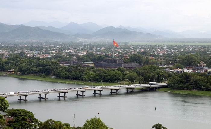
Imperial cuisine for which this city is rightly famous. On the banks of
the enigmatically named
Perfume River, the peculiar light of this
historic place imbues photographs with a hazy, purple tinge. It would
all be quite idyllic if it weren't for the constant dogging most
tourists face as soon as they step off the bus. The touts in Hue are
more incessant than most. While the offshoots of mass tourism may be
annoying, it should be remembered that
Hue's cultural sites were
destined for oblivion without it. After 1975 they were left to decay
-Imperialist reminders of the feudal Nguyen dynasty. In 1990 that the
local People's Committee recognised the potential of the place and
declared these sites 'national treasures'. In 1993 Unesco designated the
complex of monuments in Hue a World Heritage site, and restoration and
preservation work continues. The Festival of Hue is celebrated
biennially in even-numbered years, with local and international cultural
performers at locations throughout the city.
Hotel accommodation is at a
premium at this time, so book ahead if you can.
The citadel city of Phu Xuan was built in 1687, 5km northeast of
present-day Hue. In 1744 Phu Xuan became the capital of the southern
part of Vietnam, which was under the rule of the Nguyen lords. The Tay
Son Rebels occupied the city from 1786 until 1802, when it fell to
Nguyen Anh. He crowned himself Emperor Gia Long, thus founding the
Nguyen dynasty, which ruled the country - at least in name - until 1945.
In 1885, when the advisers of 13-year-old Emperor Ham Nghi objected to
French activities in Tonkin, French forces encircled the city. Unwisely,
the outnumbered Vietnamese forces launched an attack; the French
responded mercilessly. According to a contemporary French account, the
French forces took three days to burn the imperial library and remove
from the palace every single object of value - everything from gold and
silver ornaments to mosquito nets and toothpicks. Ham Nghi fled to Laos.
but he was eventually captured and exiled to Algeria. The French
replaced him with the more pliable Dong Khanh, thus ending any pretence
of genuine independence for Vietnam. Hue was the site of the bloodiest
battles of the 1968 Tet Offensive and was the only city in
South Vietnam
to be held by the Communists for more than a few days. While the
American command was concentrating its energies on
Khe Sanh,
North Vietnamese and VC troops skirted the American stronghold and
walked right into Hue.
Sights & Activities
CITADEL
Most of Hue's sights and a sizeable chunk of its population reside
within the 2m-thick, 10km-long walls of its Citadel (Kinh Thanh) on the
north bank of the river. Begun in 1804 on a site chosen by Emperor Gia
Long's geomancers, it was originally made of earth and later
strengthened with brick. Roughly square shaped, three sides of the
Citadel are straight; the fourth is rounded
slightly to follow the curve of the river. The ramparts are encircled by
a zigzag moat, which is 30m across and about 4m deep. There are 10
fortified gates, each accessed via a bridge. In the northern corner of
the Citadel is Mang Ca Fortress, which is still used as a military base.
At the centre of the wall facing the river, the 37m-high
Flag Tower (Cot Co) is Vietnam's tallest
flagpole. Erected in 1809 and extended in 1831, it was knocked down in
1904 by a typhoon that devastated the city. It was rebuilt in 1915 only
to be destroyed again in 1947. Two years later it was erected once
again, in its present form. During the VC occupation in 1968, the
National Liberation Front flag flew defiantly from the tower for 31/2
weeks. Located just inside the Citadel ramparts, near the gates to
either side of the Flag Tower, the Nine Holy
Cannons, symbolic protectors of the palace and kingdom, were cast
in 1804 from brass captured from the Tay Son Rebels. Commissioned by
Emperor Gia Long, they were never intended to be fired. Each is 5m long,
has a bore of 23cm and weighs about 10 tonnes. The four cannons near
Ngan Gate represent the four seasons, while the five cannons next
to Quang Duc Date represent the five
dements: metal, wood, water, fire and earth.
Ngo Mon Gate

The principal entrance to the Imperial Enclo sure is Ngo Mon Gate
(Noontime Gate; 1833), which faces the Flag Tower. The central
passageway with its yellow doors was reserved for the use of the
emperor, as was the bridge across the lotus pond. Other mere mortals had
to use the gates to either side and the paths around the pond. On top of
the gate is Ngu Phung (Belvedere of the Five Phoenixes), where the
emperor appeared on important occasions, most notably for the
promulgation of the lunar calendar- On 30 August 1945 the Nguyen dynasty
ended here when Emperor Bao Dai abdicated to a delegation sent by Ho Chi
Minh's Provisional Revolutionary Government.
Forbidden Purple City
Behind the palaces, in the very centre of the Imperial Enclosure, the
Forbidden Purple City (Tu Cam Thanh) is a
citadel-within-a-citadel-within-a-citadel. Reserved solely for the
personal use of the emperor, the only servants allowed into this
compound were eunuchs who would pose no threat to the royal concubines.
It was al??most entirely destroyed in the wars, and a large part is now
draped in green foliage. Take care as you wander around the ruins as
there are some gaping holes. To the right the Royal Theatre, begun in 1826 and later home to the National
Conservatory of Music, has been rebuilt on the former foundations.
Cultural performances are held here daily at 9am, 10am. 2.30pm and
3.30pm. Behind this, the two-storey Emperor's Reading Room (Thai Binh
Lau), decorated with interesting roof mosaics, was the only part of the
Forbidden Purple City to have escaped damage during the French
reoccupation of Hue in 1947.
AROUND HUE
Thien Mu
Pagoda

Built on a hillock overlooking the perfume River, 4km southwest of the
Citadel, this pagoda (Linh Mu; admission
free) is an icon of Vietnam, The existing 21m -high octagonal tower,
Thap Phuoc Duyen, was constructed under the reign of Emperor Thieu Tri
in 1844 and has become the unofficial symbol of the city. Each of the
seven storeys is dedicated to a manushi-buddha, which is a Buddha 1 hat
appeared in human form. Thien Mu Pagoda was originally founded in 1601
by Nguyen Hoang, governor of Thuan Hoa province. According to legend, a
Fairy Woman (Thien Mu) appeared and told the people that a lord would
come to build a pagoda for the country's prosperity. On hearing this,
Nguyen Hoang ordered a pagoda to be constructed here. Over the centuries
its buildings have been destroyed and rebuilt several times. Since the
1960s it has been a flashpoint of political demonstrations. To the right
of the tower is a pavilion containing a stele dating from 1715. It is
set on the back of a massive marble turtle, a symbol of longevity. To
the left of the tower is another six-sided pavilion, this one sheltering
an enormous bell, Dai Hong Chung, which was cast in 1710 and weighs
2052kg; it is said to be audible 10km away. In the main sanctuary, in a
case behind the bronze laughing Buddha, are three statues: A Di Da, the
Buddha of the Past; Thich Ca, the historical Buddha (Sakyamuni); and Di
Lac Buddha, the Buddha of the Future. For a nice bicycle ride, head
southwest (parallel to the Perfume River) on riverside Đ Tran Hung Dao,
which turns into Đ Le Duan after passing Phu Xuan Bridge. Cross the
railway tracks and keep going on Đ Kim Long.
Thien Mu Pagoda can also be
reached by dragon boat and a visit is included in most city tours.
Royal Tombs

The
tombs of the rulers of the Nguyen dynasty (1802-1945) are extravagant
mausoleums, constructed along the banks of the Perfume River between 2km
and 16km south of Hue. While many of the tombs can be reached by boat,
you'll have more time to enjoy them by renting your own bicycle or
motorbike - if getting lost is part of the fun - or hiring a xe om
(motorbike taxis) or car for the day.
TOMB OF TU DUC
The majestic and serene tomb of Tu Duc
is set amid frangipani and pine trees. Emperor Tu
Duc designed the exquisitely harmonious tomb, which was constructed
between 1864 and 1867, for use both before and after his death. The
enormous expense of the tomb and the forced labour used in its
construction spawned a coup plot that was discovered and suppressed in
1866. It is said that Tu Duc, who had the longest reign of any Nguyen
monarch (1848-83), lived a life of ultimate imperial luxury. Though he
had 104 wives and countless concubines, he had no offspring. One theory
has it that he became sterile after contracting smallpox. His tomb is
entered from the southeast via Vu Khiem Gate. A path leads to a boat
landing on the shore of a lake. The island to the right is where Tu Duc
used to hunt small game. Across the water to the left is Xung Khiem
Pavilion, built on piles over the water, where the emperor would sit
among the columns with his concubines, composing or reciting poetry.
Across the courtyard from the landing are steps leading to Hoa Khiem
Temple, where Tu Duc and Empress Hoang Le Thien Anh (Tu Duc's wife) are
worshipped. Before his death, Tu Duc used this as a palace, staying here
during his long visits to the complex. It contains a number of
interesting items, including two thrones, the larger of which was for
the empress (Tu Duc was only 153cm tall). Minh Khiem Chamber, to the
right behind Hoa Khiem Temple, was originally built for use as a
theatre. Tu Duc's mother, Tu Duc, is worshipped in Luong Khiem Temple,
directly behind Hoa Khiem Temple. At the bottom of the stairway, the
path continues along the shore of the lake to the Honour Courtyard.
Across the lake are the tombs of Tu Duc's adopted son, Emperor Kien Phuc,
who ruled for only seven months (1883-84), and Empress Hoang Le Thien
Anh. After walking between the honour guard of elephants, horses and
diminutive mandarins (they were made even shorter than the emperor), you
reach the Stele Pavilion, which shelters a stone tablet weighing about
20 tonnes. It took four years to transport the stele, the largest in
Vietnam, 500km from near Thanh Hoa in the north. Tu Duc drafted the
inscriptions himself in order to clarify certain aspects of his reign.
He freely admitted that he had made mistakes and chose to name his tomb
Khiem, which means 'modest’. The two nearby towers symbolise the
emperor's power.Tu Duc's tomb, enclosed by a wall, is on the other side
of a half-moon-shaped Iake, He was never actually interred here. The sit
where his remains were buried (along with great treasure) is not known.
Because of the danger of grave robbers, extreme measures were taken to
keep the location secret - every one of the 200 serv ants who buried the
king was beheaded. Tu Duc's tomb is about 5km south ol Hue on Van Nien
Hill in Duong Xuan Thuong Village,
TOMB OF DONG KHANH
The smallest of the Royal Tombs, Dong Khanh's
mausoleum (admission 30,000d) was built in 1889. Emperor Dong
Khanh was the nephew and adopted son of Tu Duc, and was placed on the
throne by the French after they captured his predecessor, Ham Nghi.
Predictably, Dong Khanh proved docile; he ruled from 1885 until his
death three years later. Seldom visited, there is a certain serenity
here. It is just over 5km from the city, 500m behind the tomb of Tu Duc
A FIERY PROTEST
Behind the main sanctuary of the Thien Mu Pagoda is the Austin motorcar
that transported the monk Thich Quang Duc to the site of his 1963 ,self
immolation. Thich Quang Duc travelled to Saigon and publicly burned
himself to death to protest the policies of South Vietnamese President
Ngo Dinh Diem. A famous photograph of his act was printed on the front
pages of newspapers around the world. His death soon inspired a number
of other self-immolations. The response of the president's notorious
sister-in-law, Tran Le Xuan (Madame Nhu), was to happily proclaim the
self-immolations a 'barbecue party', saying 'Let them burn and we shall
clap our hands'. Her statements greatly added to the already substantial
public disgust with Diem's regime; the US press labelled Madame Nhu the
Iron Butterfly' and Dragon Lady'. In November both President Diem and
his brother Ngo Dinh Nhu (Madame Nhu's husband) were assassinated by
Diem's own military. Madame Nhu was oversias at the time. Another
self-immolation sparked more protest in 1993. In this instance a man
arrived at the pagoda and, after leaving offerings, set himself alight
chanting the word 'Buddha'. Although the man's motivation remains a
mystery, this set off a chain of events whereby the pagoda's leading
monks were arrested, linked with the independent United Buddhist Church
of Vietnam, the banned alternative to the state-sanctioned Vietnam
Buddhist Church. This led to an official complaint to the UN by the
international Federation of Human Rights accusing the Vietnamese
government of violating its own constitution, protecting freedom of
religion.
TOMB OF THIEU TRI
Construction of the tomb of Thieu Tri, who ruled from 1841 to 1847, was completed in 1848-
It is the only Royal Tomb not enclosed by a wall. The tomb has a similar
floor plan to his father Minh Mang’s tomb but is substantially smaller.
During his lifetime, an effort to preserve Vietnamese independence by
cracking down on missionaries resulted in a French naval attack in 1847,
where Vietnam's coastal forts were destroyed and three junks sunk. The
emperor's response was to decree that all Christians be summarily
executed. The orders were never followed and Thieu Tri died shortly
afterwards. The tomb is about 7km from Hue, in a peaceful rural
landscape, and is off the tour bus trail. If you're walking, cycling or
on a motorbike, there's a pretty 2km or so cross country track that
leads here from the tomb of Dong Khanh.
REGAL RESTING PLACES
Although all are unique in structure and design, most of the mausoleums
consist of five parts. A stele pavilion in which the accomplishments ,
exploits and virtues of the deceased emperor are engraved on a marble
tablet, usually written by the dead ruler's successor. A temple for the
worship of the emperor and empress. In front of each altar, on which the
deceased ruler's funerary tablets were placed, is an ornate dais that
once held items the emperor used every day. such as his betel-nut trays
and cigarette cases. A sepulchre, usually inside a square or circular
enclosure, where the emperor's remains are buried. An honour courtyard
paved with dark-brown bat trang bricks, along the sides of which stand
stone elephants, horses, and civil and military mandarins. The civil
mandarins wear square hats and hold an ivory sceptre, the symbol of
their authority; the military mandarins wear round hats and hold swords,
A lotus pond surrounded by fangipani and pine trees, Almost ail of the
tombs, which are in walled compounds, were planned by the Nguyen
emperors during their lifetimes. Many of the precious ornaments that
were once reposited in the tombs disappeared during Vietnam's wars
TOMB OF KHAI DINH
The hillside tomb of Khai Dinh (admission
55,000d), who ruled from 1916 to 1925, is perhaps symptomatic of the
decline of Vietnamese culture during the colonial era. Begun in 1920 and
completed in 1931, the grandiose concrete structure is completely unlike
Hues other tombs, being a synthesis of Vietnamese and European elements.
Even the stone faces of the mandarin honour guards are endowed with a
mixture of Vietnamese and European features. After climbing 36 steps
between four dragon banisters, you reach the first court yard, flanked
by two pavilions. The Honour Courtyard, with its rows of elephants,
horses and mandarins, is 26 steps further up the hillside. In the centre
of the courtyard ;is an octagonal Stele Pavilion. Up three more flights
of stairs is the main building, Thien Dinh, which is divided into three
halls. The walls and ceiling are decorated with murals of the Four
Seasons, Eight Precious Objects and Eight Fairies. Under a graceless,
one-tonne concrete canopy is a gilt bronze statue of Khai Dinh in
regalia. His remains are interred 18m below the statue and he is
worshipped in the last hall. The tomb of Khai Dinh is 10km from Hue, in
Chau Chu Village.
TOMB OF MINH MANG
Perhaps the most majestic of all of the Royal Tombs is that of
Minh Mang (admission 55,000d), who ruled
from 1820 to 1840. Renowned for its architecture, which harmoniously
blends into the natural surroundings, the tomb was planned during Minh
Mang's lifetime and built between 1841 and 1843 by his successor. The
Honour Courtyard is reached via three gates on the eastern side of the
wall. Three gates staircases lead from the courtyard to the square Stele
Pavilion (Dinh Vuong). Nearby there once stood an altar on which
buffaloes, horses and pigs were sacrificed. Sung An Temple, dedicated to
Minh Mang and his empress, is reached via three terraces and Hien Duc
Gate. On the other side of the temple, three stone bridges span Trung
Minh Ho (Lake of Impeccable Clarity). The central bridge, Cau Trung Dao,
constructed of marble, was for the emperor's use only. Minh Lau Pavilion
stands on the top of three superimposed terraces that represent the
'three powers': the heavens, the earth and water. Visible to the left is
the Fresh Air Pavilion; the Angling Pavilion is to the right. From a
stone bridge across crescent-shaped Tan Nguyet Lake (Lake of the New
Moon), a monumental staircase with dragon banisters leads to the
sepulchre, which is surrounded by a circular wall symbolising the sun.
Behind the bronze door in the middle of the enclosure is the emperor's
burial place: a mound of earth covered with mature pine trees and dense
shrubbery. The tomb of Minh Mang, which is on Cam Ke Hill in An Bang
Village, is over the bridge on the west bank of the Perfume River, about
12km from Hue.
TOMB OF GIA LONG
Emperor Gia Long, who founded the Nguyen dynasty in 1802 and ruled until
1819, ordered the construction of his tomb in 1814. According to royal
annals, the emperor himself chose the site after scouting the area on
the back of an elephant. The rarely visited tomb (admission free), which
is presently in a state of ruin, is around 14km south of Hue and 3km
from the west bank of the Perfume River. Temple of
Nam Giao: The Temple of Nam Giao
(Temple of Heaven; admission free} was once the most important religious
site in all of Vietnam, It was here that, every three years, the emperor
solemnly offered elaborate sacrifices to the All-Highest Emperor of the
August Heaven (Thuong De). The topmost esplanade, which represents
heaven, is round, while the middle terrace, representing earth, is
square, as is the lowest terrace representing humanity. After
reunification, the provincial government erected an obelisk in memory of
soldiers killed in the American War on the site where the sacrificial
altar had once stood. There was strong public sentiment in Hue against
the obelisk and it was finally torn down in 1993. Nam Giao remains
unrestored and crumbling. To find it, head south on Đ Dien Bien Phu for
nearly 2km after the railway tracks.
Thanh Toan Bridge

Situated 7km east of central Hue, the
Thanh Toan Bridge is a classic
covered Japanese foot bridge. Architecturally similar to its cousin in
Hoi An, it receives far fewer visitors - it's mostly used by local
villagers for naps in the shady walkway. The bridge is best reached by
motorbike or bicycle. Finding it is a bit tricky, but tolerable if you
consider getting lost part of the excursion. Head north for a few
hundred metres on Đ Ba Trieu until you see a sign to the Citadel Hotel.
Turn right here and follow the bumpy dirt road for another 6km past
villages, rice paddies and several pagodas until you reach the bridge.
Ho Quyen Coloseum (Tigers Arena)

Thuan An beach
to "Dead City"
Thuan An Beach, 15km northeast of Hue, is on a splendid lagoon near the
mouth of the Perfume River, at the tip of a long, thin island. It's
lovely for beachcombing, and is quite undeveloped except for a few
kiosks, but between September and April the water's often too rough to
swim in. It is joined to the mainland by a short bridge, and beyond the
beach a 50km scenic road (actually Hwy 49, though you'd never guess)
stretches the length of the undeveloped island (no maps give it a name)
from Thuan An to Vinh Hien. This makes a
great day trip by motorbike or
car from Hue. It also offers an alternative route to or from Hue for travellers making their way on two wheels along the coast road. Coming
from Thuan An, the island is skinny and the road winds along with the
lagoon on one side and the ocean on the other. There are several
villages on the way with stacks of enormous nuoc mam (fish sauce) jars
lining the outer walls of many houses, and miles of fertile raised
vegetable gardens. But most extraordinary are the vast, colourful and
opulent graves and family temples lining the ocean side of the road;
there are thousands upon thousands of them. In Vietnam the area is known
as the 'city of tombs', with families vying to outdo their neighbours'
ancestral monuments. There was a huge outflow of boat people from this
area and the overseas Vietnamese now provide the funds to construct
these excessive structures
PHONG NHA CAVE

The complex karst formations stretching throughout the surrounding Ke
Bang National Park were formed approximately 400 million years ago,
making them the oldest in Asia. Part of this system,
Phong Nha Cave is the largest and most
beautiful cave in Vietnam. Located in the village of Son Trach, 55km
northwest of
Dong Hoi, it was designated a Unesco World Heritage site in
2003. It's remarkable for its thousands of metres of underground
passageways and river caves filled with abundant stalactites and
stalagmites. In November and December the river is prone to flooding and
the under ground cave may be closed. Phong Nha means Cave of Teeth, but,
unfortunately, the 'teeth' (or stalagmites) that were by the entrance
are no longer there. Once you get further into the cave, it's mostly
unspoiled. In 1990 a British expedition explored 35km of the cave and
made the first reliable map of the underground (and underwater)
passageways. They discovered that the main cavern is nearly 8km long,
with 14 other caves nearby. Tien Son Cave
(tell: 675110; admission 20,000d; 7am-4pm) is a dry cave in the
mountainside just above Phong Nha Cave. You can walk to it from the
entrance to
Phong Nha Cave (10 minutes) - look for the sign at the foot
of the stairs. The Chams used the cave's grottoes as Hindu sanctuaries
in the 9th and 10th centuries; the remains of their altars and
inscriptions are still here. Vietnamese Buddhists continue to venerate
these sanctuaries, as they do other Cham religious sites. More recently,
this cave was used as a hospital and ammunition depot during the
American War. The entrance shows evidence of aerial attacks. That US
war-planes spent considerable time bombing and strafing the Phong Nha
area is hardly surprising: this was one of the key entrance points to
the Ho Chi Minh Trail. Some overgrown remains of the trail are still
visible, though you'll need a guide to point them out to you. You should
be aware that Phong Nha is heavily visited by Vietnamese groups. The
cave itself is fantastic, the experience less so. That is, unless you
like your World Heritage sites to incorporate litter, noise, people
climbing on stalagmites and cigarette smoke in confined spaces. Of
course these things are prohibited, but enforcement is lax to say the
least. Presumably these distractions can be avoided if you arrive early
in the morning. The toilets might be less putrid then, too.
DEMILITARISED ZONE (DMZ)
The
Vietnam War (as the West knows it) shaped the culture of a whole
generation throughout much of the world. The incredible output of films,
TV shows and music relating to the war is testimony to that. While it
may seem a little ghoulish, it's understandable that many tourists want
to visit the names engraved in their consciousness - and not just the
steady stream of Vets revisiting the places that changed their lives.
From 1954 to 1975 the Ben Hai River served as the demarcation line
between the Republic of Vietnam (RVN; South Vietnam) and the Democratic
Republic of Vietnam (DRV;
North Vietnam). On cither side of the river
was an area 5km wide that was known as the
Demilitarised Zone (DMZ).
Ironically, as the conflict escalated, it became one of the most militarised zones in the world.
History
The idea of partitioning Vietnam had its origins in a series of
agreements concluded between the USA. UK and the USSR at the Potsdam
Conference, held in Berlin in July 1945. For logistical and political
reasons, the Allies decided that the Japanese occupation forces to the
south of the 16th Parallel would surrender to the British while those to
the north would surrender to the Kuomintang (Nationalist) Chinese army
led by Chiang Kaishek. This was despite the Viet Minh being in control
of the country by September that year - Vietnam's first real taste of
independence since 1887. In April 1954 at Geneva, Ho Chi Minh's
government and the French agreed to an armistice; among the provisions
was the creation of a demilitarised zone at the Ben Hai River. The
agreement stated explicitly that the division of Vietnam into two zones
was merely temporary and that the demarcation line did not constitute a
political boundary. But when nationwide general elections planned for
July 1956 were cancelled by the South who predicted a Viet Minh win,
Vietnam found itself divided into two states with the Ben Hai River,
which is almost exactly at the 17th Parallel, as their de facto border.
During the American War, the area just south of the DMZ was the scene of
some of the bloodiest battles of the conflict. Quang Tri, The Rockpile,
Khe Sanh, Lang Vay and Hamburger Hill became household names in the USA
as, year after year, TV pictures and casualty figures provided Americans
with their evening dose of war. Since 1975,5000 people have been injured
or killed in and around the DMZ by mines and ordnance left over from the
war. Despite the risk, impoverished peasants still dig for chunks of
leftover metal to sell as scrap, for which they are paid a pittance.
VINH MOC TUNNELS

The incredible tunnels of Vinh Moc (admission 15,000d; Time 7am-4.30pm)
are a monument to the perseverance of the North Vietnamese. The 2.8km of
tunnels, all of which can be visited, are the real thing and
unadulterated for viewing by tourists, unlike the
tunnels at Cu Chi. Vinh Moc's underground passageways are larger and taller than those at
Cu Chi, which makes for an easier and slightly less claustrophobic
visit. There are lights installed inside the tunnels, but you may also
want to bring a torch (flashlight). There's an interesting museum on
site, housing photos and relics of tunnel life. Outside, American bomb
casings are dotted around everywhere, as are the craters that they
created. A visit to the tunnels can be combined with bathing at the
beaches that extend for many kilometres to the north and south. The
turn-off to Vinh Moc from Hwy 1A is 6.5km north of the Ben Hai River in
the village of Ho Xa. Follow this road east for 13km.
CUA TUNG BEACH
This long, secluded stretch of sand, where Vietnam's last emperor, Bao
Dai, used to holiday, is just north of the mouth of the Ben Hai. There
are beaches on the southern side of the Ben Hai River as well. Every bit
of land in the area not levelled for planting is pockmarked with big
bomb craters. There are no buses to
Cua Tung Beach, which can be reached
by turning east off Hwy 1A at a point 1.2km north of the Ben Hai River.
Cua Tung Beach is about 7km south of Vinh Moc via the dirt road that
runs along the coast.
GOING UNDERGROUND
In 1966 the USA began a massive aerial and artillery bombardment of
North Vietnam. Just north of the DMZ, the villagers of Vinh Moc found
themselves living in one of the most heavily bombed and shelled strips
of land on the planet. Small family shelters could not withstand this
onslaught and villagers either fled or began tunnelling by hand into the
red-clay earth. The Viet Cong (VC) found it useful to have a base here
and encouraged the villagers to stay, After 18 months of work, during
which the excavated earth was camouflaged to prevent its detection from
the air, an enormous complex was established underground. Civilians were
employed in the digging and were accommodated in new underground homes.
Whole families lived here and 17 babies were born in the underground
delivery room. Later, the civilians and VC were joined by North
Vietnamese soldiers, whose mission was to keep communications and supply
lines to nearby Con Co Island open. Other villages north of the DMZ also
built tunnel systems, but none was as elaborate as Vinh Moc. The poorly
constructed tunnels of Vinh Quang village (at the mouth of the Ben Hai
River) collapsed after repeated bombing, killing everyone inside. The
tunnel network at Vinh Moc remains essentially as it looked in 1966,
though some of the 12 entrances - seven of which open onto the
palm-lined beach - have been retimbered and others have become
overgrown. The tunnels were built on three levels ranging from 12m to
23m below the crest of the bluff. US warships stationed off the coast
consistently bombarded the tunnels, but the only ordnance that posed a
real threat was the feared 'drilling bomb'. Only once did such a bomb
score a direct hit, but it failed to explode and no-one was injured; the
inhabitants adapted the bomb hole for use as an air shaft. Occasionally
the mouths of the tunnel complex that faced the sea were struck by naval
gunfire.
BEN HAI RIVER
Twenty-two kilometres north of Dong Ha, Hwy 1A crosses the Ben Hai
River, once the demarcation line between North and South Vietnam. Check
out the old wartime bridge until 1967, when it was bombed by the
Americans, the northern half of the bridge that stood on this site was
painted red, while the southern half was yellow. Following the signing
of the Paris cease-fire agreements
in 1973, the present bridge and the two flag towers were built.
TRUONG SON NATIONAL CEMETERY
Truong Son National Cemetery is a sobering memorial to the tens of
thousands of North Vietnamese soldiers who were killed in the Truong Son
Mountain Range along the
Ho Chi Minh Trail. Row after row of white
tombstones stretch across the hillsides. The cemetery is maintained by
disabled war veterans. The soldiers are buried in five zones according
to the part of Vietnam they came from, and each zone is further
subdivided into provinces. The gravestones of five colonels and seven
decorated heroes, including one woman, are in a separate area. Each
headstone bears the inscription 'Liet Si', which means martyr. The
remains of soldiers interred here were originally buried near the spot
where they were killed and were brought here after reunification. Many
graves are empty, simply bearing the names of a small number of
Vietnam's 300,000 MIAs. The site where the cemetery now stands was used
as a base by the May 1959 Army Corps from 1972 to 1975. Named after the
date on which they were founded, they had the mission of constructing
and maintaining a supply line to the South - the legendary Ho Chi Minh
Trail. On the hilltop above the sculpture garden is a three-sided stele
with inscriptions paying tribute to this corps and outlining their
history. The road to Truong Son National Cemetery intersects Hwy 1A 13km
north of Dong Ha and 9km south of the Ben Hai River; the distance from
the highway to the cemetery is 17km. A rocky path that is passable by
motorbike links Cam Lo (on Hwy 9) with Truong Son National Cemetery
(18km). This track passes rubber plantations and also the homes of Bru
(Van Kieu) people, who cultivate, among many other crops, black pepper.
Military Sites on Highway 9
The legendary Ho Chi Minh Trail - the main artery of supplies for the
North's war effort-was not one path but many, leading through the
jungles of the country's mountainous western spine. In an effort to cut
the line near the border, the Americans established a series of bases
along Hwy 9, including (from west to east) Lang Vay, Khe Sanh, Ca Lu
(now called Dakrong Town), The Rockpile, Camp Carroll, Cam Lo, Dong Ha,
Gio Linh and Cua Viet. Ultimately their efforts were unsuccessful.
KHE SANH COMBAT BASE
The site of the most famous siege - and one of the most controversial
battles-of the American War, Khe Sanh Combat Base sits silently on a barren plateau, surrounded by
vegetation-covered hills that are often obscured by mist and fog. It is
hard to imagine as you stand in this peaceful, verdant land that in
early 1968 the bloodiest battle of the war took place here. About 500
Americans (the official figure of 205 was arrived at by statistical
sleight of hand), 10,000 North Vietnamese troops and uncounted civilian
bystanders died amid the din of machine guns and the fiery explosions of
1000kg bombs, white-phosphorus shells, napalm, mortars and artillery
rounds of all sorts.
The site includes the recent addition of a small memorial museum. A
couple of bunkers have been recreated and some photos and other
memorabilia are on show. Behind the main site, the outline of the
airfield remains distinct - to this day nothing will grow on it. Some of
the comments in the visitors' book, especially those written by visiting
war veterans, can make for emotional reading. A MIA team still visits
the area regularly to search for the bodies of Americans who disappeared
during the fierce battles in the surrounding hills. Most remains they
find are Vietnamese.
Source: lonely planet


